


Milwaukee County Coastal Resources Inventory
This project was funded as part of the Southeastern Wisconsin Coastal Resilience project led by the Wisconsin Coastal Management Program. To be eligible for this funding, Lake Michigan coastal local governments in Kenosha, Racine, Milwaukee, and Ozaukee counties completed a Coastal Resilience Self-Assessment (link) to help prioritize top coastal hazard concerns and identify potential planning and mitigation practices to address these hazards. Local governments used the results of their assessment to develop projects that would help address priority needs identified in the assessment in order to enhance their capacity to plan, prepare for and adapt to coastal hazards.
Funding for this project was provided by the National Atmospheric and Oceanic Administration (NOAA) Coastal Resilience Grants Program, Grant # NA17NOS4730144.
 Title of Project: Milwaukee County Coastal Resources Inventory
Organization applying: Milwaukee County
Total project cost: $70,760.00
Grant award: $41,800.00
A PDF of this case study with more details is available here: Milwaukee County Full Case Study Final
Collaborators
- Milwaukee County
- Environmental Services Unit
- Parks Department
- Land Information Office
- Wisconsin Sea Grant Institute
- Southeastern Wisconsin Regional Planning Commission
The Coastal Resilience Issue
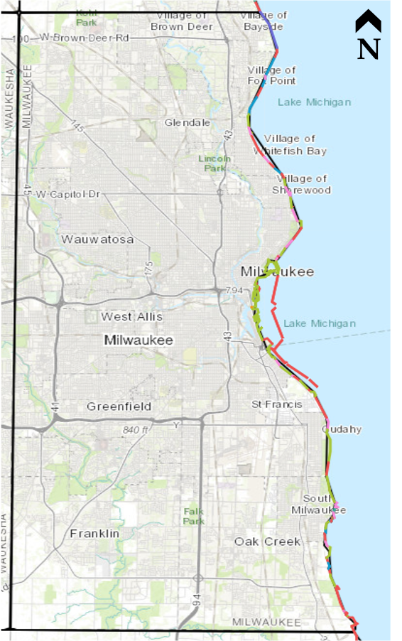
Milwaukee County owns about 9 miles of lakefront along the Lake Michigan shoreline, primarily as part of the Milwaukee County Park System. The Lake Michigan coast is home to many popular Milwaukee County Parks which include sand beaches, cobble shorelines, vegetated bluffs, environmental corridors, nature trails, picnic areas, boat launches, and marinas. These parks contain various types of infrastructure such as paved walks, park roads, stormwater management features, and shore protection structures.
Extreme weather has damaged Milwaukee County’s coastal resources and it is anticipated that damaging events will continue to occur in the future, with the possibility that the severity will be greater due to the effects of climate change. Extremely high lake levels in 2019 and 2020 had a significant impact on shoreline erosion and beach sand movement. For example, in a January 2020 storm, damages to park property were expected to require about $8 million in repairs.
Vision for the Community
Milwaukee County wants to be strategic in planning how to protect priority shoreline and coastal resources from ongoing erosion and flooding damage so the public can enjoy recreational pursuits along the lake and throughout the County lakeshore parks.
The Need
There was a need to develop a comprehensive asset analysis and inventory of Milwaukee County’s coastal resources to systematically determine:
- What infrastructure and assets exist?
- What condition they are in?
- What needs to be done to get ahead of impairment due to age and weather damaged?
The goal is to be able to form a plan that is preventative instead of reactive to changing Lake conditions.
What was accomplished
The project inventoried coastal resources along Milwaukee County’s Lake Michigan Coast, summarized their current status, assigned economic values to those resources, and prioritized them according to vulnerability and value.
This project involved five stages:
1) Asset Inventory: An asset was considered in this inventory if it was likely to experience coastal hazard impacts, defined as the area from the lakebed to a distance 427 feet landward of the This area of interest was determined based on the horizontal distance a high bluff top edge would be expected to recede back to a 2.5-to-1 stable slope, plus a 100 foot factor of safety buffer. A total of 477 coastal assets were inventoried in this area of interest across 16 different categories.
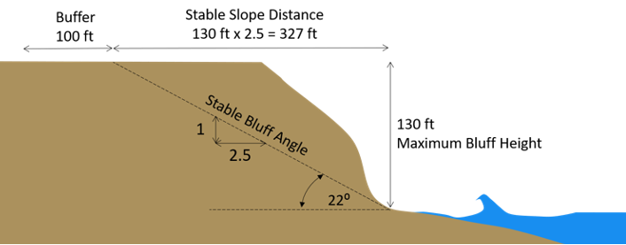 Figure 1: Diagram depicting stable slope distance calculation to determine area of interest
2) Condition Assessment: A unique set of metrics was developed for each asset category to rate the condition of the asset itself as either poor, fair, or good. When possible, existing rating systems for some asset classes (e.g. paved surfaces) were adapted into these metrics. Other asset classes, like shore protection structures, required a field inspection to get an updated condition assessment.
3) Vulnerability Assessment: For each asset category, a set of weighted metrics was developed to rate vulnerability to coastal hazards as high (1 point), medium (2 points), or low (3 point). An example for athletic court vulnerability is given below. To assess an individual asset, a vulnerability score was assigned for each metric. These scores were was multiplied by the weight and summed to get a total vulnerability score for the asset. Approximately 22% of assets assessed were deemed to have high vulnerability to coastal hazards.
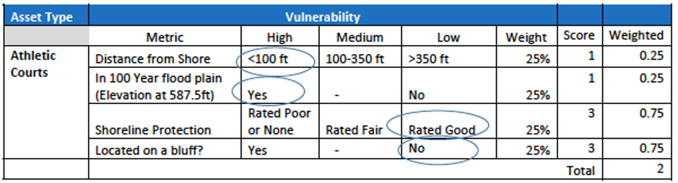
Table 1: Example of vulnerability scoring chart
4) Asset Valuation: To help compare vulnerable assets in economic terms, each asset was assigned a repair or replacement value. For example, athletic courts are most likely to be replaced in the event of substantial damage whereas existing shore protection structures are often rehabilitated rather than fully replaced.
5) Risk Score: A risk score index was developed to summarize the condition and vulnerability ratings assigned to each asset. The risk score was calculated by multiplying the condition score (from Step 2) by the vulnerability score (from Step 3). The assets were then sorted by risk score into levels of high, medium, and low priority. A total of 90 of the 477 assets were ranked a high priority based on having a risk score below 4.5.
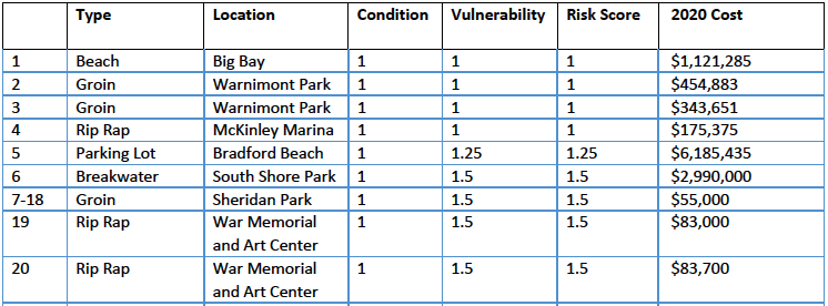 Table 2: Risk score top twenty in chart
Results
Milwaukee County inventoried all 477 of their coastal assets based on condition, vulnerability, risk and value. A total of 90 assets with a high risk to harm from coastal hazards like storms, high water levels and erosion. This assessment was documented in GIS and the resulting data was compiled into a geodatabase and an interactive map, available at the following links:
Geodatabase link
Interactive map link
Partnerships Reinforced or Made
This project strengthened relationships with experts and organizations in the field of coastal hazards. For example, the project team worked with Adam Bechle of Wisconsin Sea Grant and David Mickelson, GeoProfessional Consultants LLC, to utilize the Wisconsin Shoreline Inventory and Oblique Photo Viewer to assess bluff recession rates and shoreline changes. The team also used a cost estimating tool developed by UW Sea Grant to help assign values to port and harbor assets.
Going Forward
The inventory is an important first step in a larger effort by Milwaukee County to improve preparedness for extreme weather. The results of this analysis provides Milwaukee County with starting point of priorities to manage coastal risk throughout its nearly 9 miles of county-owned Lake Michigan shoreline. The information generated by the study will also be a useful tool during future planning of Milwaukee County’s capital improvements budgets as it will help ensure that limited local funds are used in the most cost-effective manner possible. The Milwaukee County Parks Department is also developing a Coastline Management Policy that will lay out practices for managing County‐owned lands to assist with preventing or reducing shoreline recession, bluff failure, or erosion.
Lessons Learned
- The asset inventory has provided a systematic understanding of Milwaukee County’s coastal assets and what potential future projects need to be done to preserve their use and enjoyment.
- There is not a standard of practice available regarding how to assess vulnerability to coastal hazards. County staff developed their own process to do this.
- Outside expert knowledge was gained by hiring a consultant engineer for specialized tasks like inspecting the condition of coastal structures.