


Stories about Great Lakes coastal communities working towards more resilient shorelines.
New York State’s Coastal Lakeshore Economy and Resiliency (CLEAR) Initiative
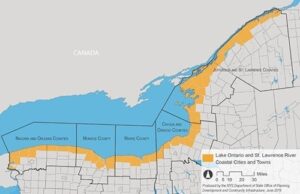
CLEAR was created to help communities in New York State manage the impacts of rising water levels of Lake Ontario, the lower Niagara River, and the upper St. Lawrence River. CLEAR has a direct set of goals found on their webpage. These goals include creating resilient communities, rebuilding with the coastal environment in mind, educating shoreline property owners, improving coastal recreation and economies, and empowering local governments, organizations, and leaders. CLEAR plans to include community stakeholders in the development of long-term plans for coastal resilience. Outreach will include workshops and community events to educate communities on erosion and flood risks, while addressing solutions in green infrastructure. Read more about the CLEAR initiative here.
Milwaukee River Estuary Cleanup
The Milwaukee Estuary is contaminated due to years of pollution. The estuary is contaminated with PCBs (polychlorinated biphenyls), PAHs (polycyclic aromatic hydrocarbons) and heavy metals that are held in the sediment and water of the rivers. The contaminates have negative effects on the wildlife, and humans have seen a disruption of the reproductive system and cancer. It was named an Area of Concern (AOC) in 1987. Since then, there has been a lot of progress made but it is still one of the most contaminated areas on the Great Lakes. Recently, the Estuary has received $400 Million in funding to help clean up the estuary. This project is estimated to remove 130,000 truckloads of material (read more about this here). Additionally, there is a new sediment contaminant facility being opened, as well as another round of dredging coming (read more about it here). These additional resources will bring the Milwaukee Estuary a step closer to clean water and beaches. Read more about additional projects, resources, and how you can help here.
Klode Park Restoration in Whitefish Bay
In January 2020, a severe winter storm damaged the beach of Klode Park in Whitefish Bay, WI. The storm eroded almost the entirety of the beach, and in some areas the beach dropped off 10 feet. The community received a federal disaster restoration and mitigation grant from the Federal Emergency Management Agency (FEMA). This grant covered 75% of the cost, while the Village of Whitefish Bay and Milwaukee equally split the remaining cost. The restoration efforts involved “burying large armor stone at the back of the beach and bottom of the bluff” (Eddie Morales) as a preventative measure to stabilize the coastline. Read the full article here.
Lake Huron Integrated Assessment
 “The Huron County Extreme Lake Levels integrated assessment was one of four projects sponsored and overseen by the University of Michigan’s Graham Sustainability Institute, and kicked off in 2015” (Lynne Peterson). Its purpose was to help lakeshore communities develop adaptive strategies to address extremes in the fluctuating lake levels and climate variation. Six themes and 23 recommendations were developed out of this project. Now, 5 years later, we interviewed the project lead and author of the assessment to see what her thoughts were. Read more about the Integrated Assessment and the Interview here.
Cleveland Metroparks Recreates Lake Erie Shoreline
 “Cleveland Metroparks and other public agencies want to transform part of the city’s East Side lakefront from a hard, mean-looking edge of sheet piling and boulders into tranquil coves and wetlands sheltered by a new offshore isle”. Cleveland Harbor Eastern Embayment Resilience Study (CHEERS) is a year-long effort to understand how to protect the lakeshore and buffer them from severe storms and water level fluctuations. Cleveland Metroparks’ plan is to use sediment dredged from the Cuyahoga River to thicken the shoreline and create about 80 acres of new parkland. Read the article here.
Who should pay for flood mitigation infrastructure?
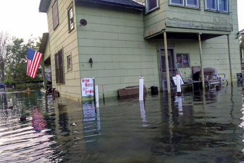 This question is becoming more and more prevalent as communities struggle to deal with fluctuating water levels, severe storms, and increasing development in and along floodplains. All of which are exacerbating flooding issues and raises the question of who’s responsibility is it to pay – private property owners or the government? This issue really hit home in the Jefferson Chalmers neighborhood of Detroit, MI. High water levels on Lake Michigan caused canals in this area to overflow and flood the streets. One solution is to build the sea walls higher. “Currently, the seawalls along more than 75 percent of the neighborhood’s 300 waterfront parcels are inadequate to protect against a 100-year flood, Simmons said. City officials have told residents that they are responsible for reinforcing the seawall on their private property — a common local government policy that protects taxpayers from footing the bill for private property improvements”. Read the full article here and about another similar situation here.
Shoreline Special Improvement District
Euclid, OH along with 12 other communities have created the first shoreline special improvement district along Lake Erie, where private property owners can be eligible for “low-interest financing to build revetments or other shoreline structures to prevent waves from [eroding] their land during increasingly frequent heavy storms and periods of high water levels”. The City of Euclid, in particular, has been able to persuaded property owners to grant easements for a shoreline trail in exchange for government-funded erosion control structures. In order for communities to join this district, they and then individual homeowners must petition to be in the special improvement district. This district could provide funding for 30-50 property owners worth up to $10 million dollars. Learn more about this project here and here.
Public Park to be Established Along Undeveloped Lake Huron Waterfront
 As part of the Lake Huron Coastal Preserve project, a 145 acre parcel along the Lake Huron coast near Tawas City, MI was purchased by Huron Pines, a Northern Michigan conservation group, and ownership will be turned over to the Alabaster Township in 2022. It was bought from a building supply manufacturing company, USG Corp., who had not been using it for mining purposes since 2000. This swath of natural shoreline “mature hardwood forest and wetland ecosystem work together as a filter to help protect the water quality of Lake Huron and support diverse plant and wildlife species, according to Huron Pines”. By turning this area into a park it will provide a place for community involvement, recreation, and coastal conservation opportunities for decades to come. Read the full story here.
Cuyahoga County Seeks Public Input to Increase Public Access to Shoreline
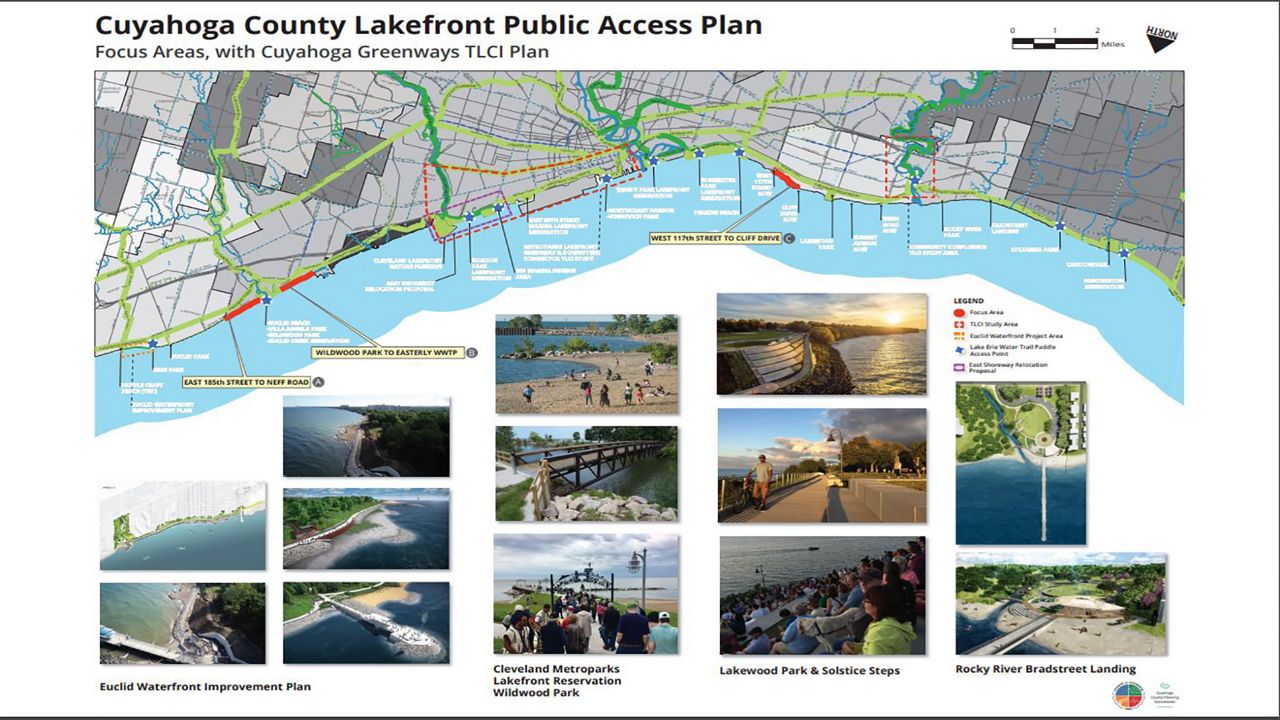
Image of Cuyahoga online survey
In Cuyahoga County, currently, 90% of the Lake Erie shoreline is private property and inaccessible to the public. Through the Lakefront Public Access Plan, the county aims to open 30 miles of shoreline focusing on “properties, roads and other infrastructure, and develop a network of interconnected bridges, roads, trails, boardwalks and paths…”. “The lake is our greatest asset, and strengthening our shoreline and providing improved access will benefit all of our residents,” Planning Executive Director Mary Cierebiej stated. One of the issues the County is looking to mitigate is discontent from lakeside property owners. So they have included a robust public engagement campaign involving online surveys, public meetings, and other forms of public engagement. Read more about it here.
Duluth Reconstructing Lakewalk to be Climate Resilient
 Like many coastal cities, The City of Duluth, MN has experienced unprecedented coastal storms and floods in the past few years. This has caused large sections of their Lakewalk to be completely washed away. After many piecemeal repairs and $30 million in cumulative damages, they decided it was time to bring in the heavy artillery. “The first line of defense is an engineered wall of giant boulders that slopes into the water just behind a few of Canal Park’s hotels.” The top layer of rocks, weighing 8 to 9 tons each, are placed on top of and held in place by even bigger boulders, up to 12 tons each, which are buried in the lake. The new Lakewalk will be elevated a few feet from its original position providing new space for pedestrians and tourists. In total, this project, involving just the 1/2 mile strip in Canal park will cost about $17 million, of which over 2/3 will be paid for by state and federal emergency funds. Read the whole story here.
Historic Shanties in Fishtown Saved from High Water Levels in MI
In Leland, MI, sandwiched between Lake Michigan and the Leland River, there exists an old Fishtown built around the early 1990s. Many of its shanties have been threatened by rising water levels. The foundations on these buildings are deteriorating and if not replaced they will eventually fall into the River. Fishtown Preservation Society (FPS) is helping to raise money for their rehabilitation. In November of 2020, the Morris Shanty was reacquainted with its rehabilitated foundation. As the oldest shanty in Fishtown “it’s been a place where Fishtown’s commercial fishing nets have been mended and stored for decades and now is tied directly to the work of FPS’s two fishing boats, the Joy and the Janice Sue.” Read the full article here.
MI Communities Strategize Lakeshore Development Policies
In Grand Haven, MI, where the shoreline remains largely free of human-made obstructions, local officials have adopted zoning changes that prevent homeowners from armoring their shoreline with seawalls or riprap. Photo credit: Jennifer Howland
Many of Michigan’s shorelines are experiencing severe erosion due to high water levels and more frequent and severe storms. In some towns, homeowners are scrambling to figure out a way to protect their homes from falling into the lake. This difficulty has led many beach communities to start creating zoning and development policies to prevent people from armoring the shores as well as building within a certain distance of the high watermark. In Grand Haven, MI “The new zoning bans shoreline protection other than fencing, though property owners can seek an exception if they can show the policy creates an ‘unnecessary hardship'”. Read more here.
Lower Fox River Cleanup
The Lower Fox River cleanup included dredging and removing 6.5 million cubic yards of contaminated sediments. Photo Credit: J.F. Brennan Company via Wisconsin DNR
17 years and $1billion later, the Fox River cleanup is finally complete. This project involved the cleanup of sediment along 39 miles of the Lower Fox River and Green Bay, where paper mills lined the river. From the mid-1950s to 1971, paper companies used polychlorinated biphenyls, or manmade chemicals known as PCBs, to make carbonless copy paper, releasing nearly 700,000 pounds into the river. Starting in 2004 and over the life of the cleanup, 6.5 million cubic yards of contaminated sediment was removed, 10 billion gallons of water was treated and returned to the river, and 800,000 tons of sand was cleaned for reuse in the river. Current tests show that contaminants in the river have been reduced by about 90% since 2006 levels.
“We’re not only closing the door on more than two decades of work on a Superfund site, but we’re also making marked improvement to the Fox River Area of Concern through the Great Lakes Restoration Initiative,” said Kurt Thiede, regional administrator for EPA’s Region 5. Read the full article here.
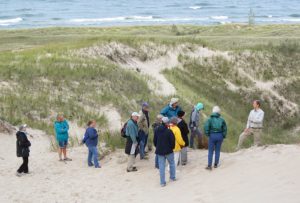
Coastal Hazards of Superior (CHAOS)
![]()
CHAOS is a newly formed community of practice organized by the Coastal programs and Sea Grant programs in Minnesota and Wisconsin, the National Oceanic and Atmospheric Administration Office for Coastal Management, and the Lake Superior National Estuarine Research Reserve. This group is an outlet for local community leaders, managers, researchers, and communicators to engage over concerns and share knowledge and resources about natural hazards that affect Lake Superior’s coastal communities in Minnesota and Wisconsin. Recent storms, flooding, and shoreline erosion have strained local communities, making CHAOS’s goal of building collaborations among groups impacted by these hazards even more important.
CHAOS sends out a monthly newsletter filled with a compilation of resources, meeting notes, events, and current news. Membership is free and open to all. To join or for more information, contact Melanie Perello at Minnesota’s Lake Superior Coastal Program: melanie.perello@state.mn.us. Read more here.
Community Resilience Action Network of Erie (CRANE), Pennsylvania
![]()
CRANE was started in the City of Erie, Pennsylvania to increase literacy surrounding climate issues. Erie County includes 76 miles of shoreline, has experienced increasing vulnerabilities related to extreme weather events, and was identified as one of the nation’s top 10 fastest-warming cities. Their mission is to “Engage the community using education and collaboration to identify climate vulnerabilities and implement proactive responses that foster a vibrant and resilient region”. In 2018 they developed a 5-year climate action strategic plan to “make the Erie community more educated, resilient, and vibrant”.
This network is an alliance between multiple organizations coming together to support and create a climate-conscious community. It includes representatives from the City of Erie, the Erie County Department of Planning and Community Development, the Green Building Alliance, Pennsylvania Sea Grant, the Pennsylvania Department of Conservation and Natural Resources, the Pennsylvania Department of Environmental Protection, and the Regional Science Consortium. Read more about CRANE.
Historic Building Relocation from Bluff in Manistee, MI
Manistee, MI. The Orchard Beach State Park Pavilion. Photo Credit: MI DNR
In Manistee, MI in Orchard Beach State Park, a 400-ton, 80-year-old, historic, limestone pavilion will be moved inland to protect it from an eroding bluff line along Lake Michigan. In its current position, the pavilion sits about 50 feet from the edge of the bluff. If not moved, it would crumble into the lake. “Higher-than-average erosion in 2019, including a mudslide, coupled with increasingly high Lake Michigan water levels spurred Barry and the Department of Natural Resources into action to save the pavilion”.
The total cost for this project will amount to about $1.5 million dollars. Funds for the relocation of the pavilion will come from a combination of capital outlay funding from the DNR in addition to savings from the park. This option is less costly and more effective than armoring the bluff, which has other consequences for the adjacent shorelines. Read the article here.
Acquisition of Shoreland for Dune Conservation
Muskegon County: Meinert Park/Flower Creek Dunes Preserve
Photo credit: Muskegon County Nature Club
The Land Conservation of West Michigan is hoping to buy 43 acres of land along the Lake Michigan shoreline. This would connect Flower Creek Dunes Nature Preserve to Meinert County Park creating 255 acres of contiguous shoreline. This conservation effort would protect a large part of Lake Michigan’s shoreline of which 75% is designated as critical duneland. This area is also a very important ecological habit for migrating butterflies and birds. “The addition of these backdunes would ensure that an indispensable natural connection within the landscape is protected forever,” April Scholtz, land protection director at the Land Conservancy of West Michigan.
Acquiring shoreland like this can help build resilience along the coast, as it keeps hazard areas as green space. It prevents development near the shore which causes erosion and it maintains native species along the shore which are better suited for the habitat and also inhibit coastal erosion. Read the full story.
Exploring Funding Options for Shore Protection
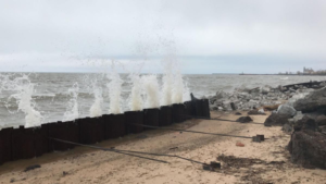
Ogden Dunes seawall battered by waves. Photo Credit: NW Indiana Times
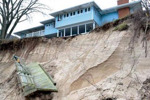
As a result of rising sea levels, Ogden Dunes, IN is looking for a way to pay for emergency repairs of the town’s sea walls. There are short-term and long-term funding opportunities that are available to them. Immediate funds can potentially be obtained by tax-deductible donations from residents. Another option is borrowing money in general obligation funds. However, the most likely short-term funding is to create a redevelopment commission and redevelopment authority. Longer-term finances may possibly be secured by setting up a conservancy district or seeking a voluntary referendum. Read the full story here.
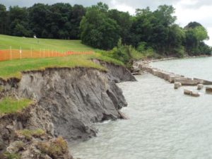
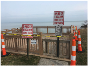
Fenced-off, erosion-damaged area of Willoughby’s Osborne Park, OH
Photo Credit: News-Herald
In 2018, bipartisan legislation was introduced that would allow the formation of special improvement districts in Ohio in order to assist homeowners in addressing coastal erosion. Homeowners could sign a petition to form a special improvement district that would allow them to seek bonding to implement projects that would otherwise be too costly to pay for individually. In 2019, a group of mayors in Lake County, Ohio worked towards developing a shared special improvement district that would help property owners address erosion of Lake Erie’s shoreline within their municipalities. From 2018-2019, Eastlake, one of the municipalities in Lake County lost up to 50 feet of shoreline in some places. North Perry, another municipality lost about 60 feet at their village hall. The special improvement district would build capacity for the homeowners in these municipalities to increase their property’s resilience to erosion.
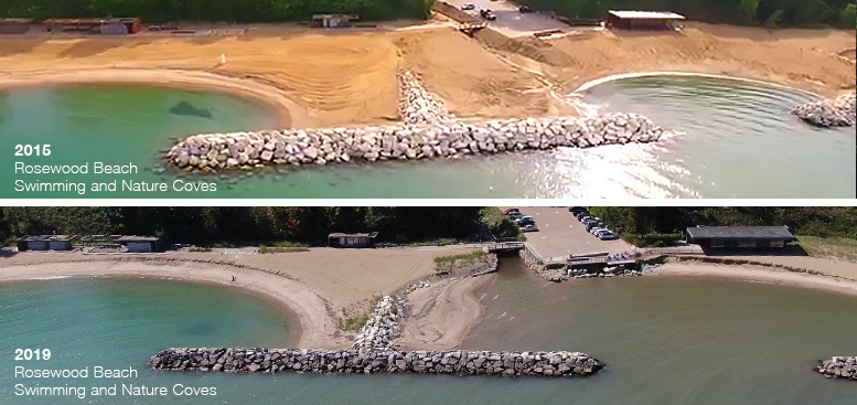 Rosewood Beach in Highland Park, Illinois is a highly used, community asset. Due to the high water levels on Lake Michigan, the beach has experienced severe sand erosion. Despite an offshore, protective revetment, continued erosion could have put park structures at risk. An emergency beach nourishment project was approved by the Park Board of Commissioners to address erosion of the shoreline and swimming coves. This nourishment project was intended to mitigate erosion from the high water levels and severe storms. Before the project began, the beach receded nearly 45 feet. Work on the project began in October 2019. Visit the Park District’s website for more details.
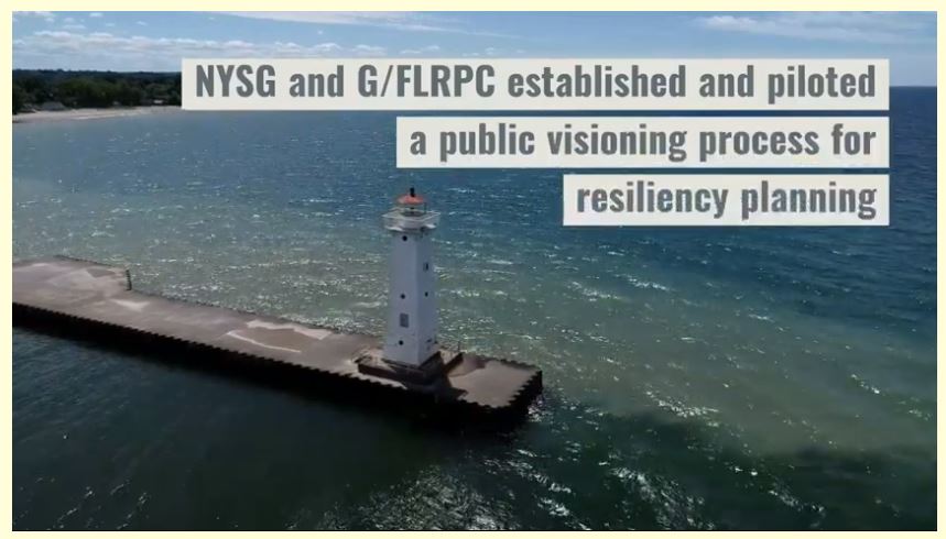 The Village of Sodus Point, NY used a visioning process piloted by the New York Sea Grant and the Genesee/Finger Lakes Regional Planning Council to help their community improve their resiliency to future flooding events. Part of the process included sharing a self-assessment checklist and hosting a public engagement workshop. Together, local residents, Village staff, Village/County department representatives, and topical experts all identified and prioritized actions that would make community assets more resilient to future flooding events. The workshop findings will be used to design rough project concepts with potential funding sources. Visit their website for more details.
.
Brandenburg Park
The seawall at Brandenburg Park
Photo Credit: Chesterfield Township
Chesterfield Township is in the process of developing shoreline restoration plans for Brandenburg Park which is regarded as “the jewel of Chesterfield Township.” The township was awarded a grant from the National Oceanic and Atmospheric Administration to assist with engineering and design fees. Shoreline erosion has led to the degradation of the existing protection structure – a steel seawall. The plans for the park will include transforming the shoreline into a ‘living shoreline,’ restoring native habitat, creating a protected harbor with a new breakwall, and installing an education station describing the project and habitat.
Euclid Waterfront Improvement Plan
Illustration by SmithGroupJJR showing part of Euclid’s lakefront plan
Photo Credit: The Plain Dealer
Through a public planning process, the city of Euclid, OH developed a Waterfront Improvement Plan that will provide public access for recreational opportunities, reclaim the City’s historic beaches, restore the coastal environment, and become a catalyst for economic investment and area-wide revitalization. The plan is organized in four sections; community vision, inventory and analysis of coastal influences and physical attributes, opportunities for improvement and enhancement, and steps for implementation. Euclid plans to take responsibility for shoreline erosion in exchange for easements that allow public access to the waterfront. Construction began in the fall of 2018 and will be completed in phases throughout 2019.
Visit the City’s website for more information and updates.
Milwaukee County Coastline Management Policy
 Funding from the Wisconsin Coastal Management Program will enable Milwaukee County Parks to inventory & prioritize the County’s coastal resources based on an assessment of the vulnerability of assets along 14 miles of the Lake Michigan shoreline to extreme weather. The coastline is currently impacted by coastal hazards such as high water levels, erosion, and coastal storms. The development of a Coastline Management Policy will assist with reducing shoreline recession, bluff failure, coastal erosion.
New Buffalo Shoreline Alliance
Shoreline near Warwick Shores Condominiums
Photo Credit: Harbor County News
The communities of Sunset Shores, Warwick Shores, Grand Beach and Forest Beach formed the New Buffalo Shoreline Alliance (NBSA) to address property damage and loss of coastal ecology due to severe beach erosion cause by high water levels on Lake Michigan. In partnership with the City of New Buffalo and the New Buffalo township, the NBSA submitted an application for a FEMA Hazard Mitigation Assistance Grant and a Great Lakes Fishery and Ecosystem Restoration Grant to help fund the installation of a series of submerged breakwaters. This project proposal includes an inter-jurisdictional effort that aims to restore the community’s beaches, economy, and coastal habitat.
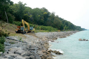
Samuel P. Meyers Park
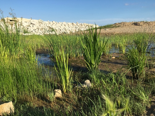
East side of coastal wetlands restoration area.
Photo Credit: Root-Pike WIN
The Racine Health Department in collaboration with Parks, Recreation, and Cultural Services and the Department of Public Works implemented a revitalization project at Samuel P. Meyers Park in Racine, Wisconsin. The effort was supported by volunteer involvement and community fundraising. The revitalization included stopping direct stormwater from reaching the shoreline, increasing accessibility to the lakefront, and restoring coastal wetlands. The City also eradicated invasive and other non-indigenous species, and planted more than 30,000 native plants that helped restore wildlife, flora and fauna. This project not only restored coastal habitat and a community resource but helped to increase coastal resiliency.
Read the full story here. For more information and updates, you can also visit this site.
Know a resilient community? Share their story with us!


