


November 6, 2018
By Adam Bechle, Coastal Resilience Outreach Specialist, Wisconsin Sea Grant
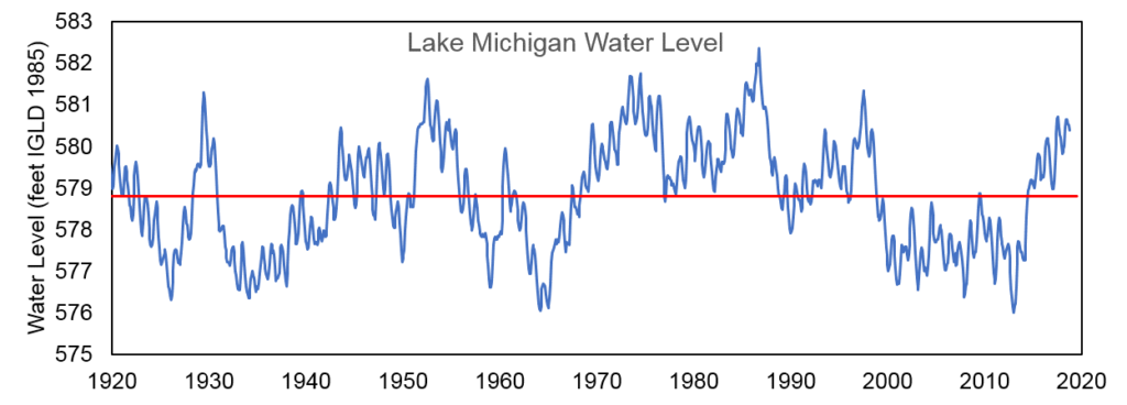
The water level of Lake Michigan as of November 2nd, 2018 is at an elevation of 580.25 feet above sea level (from the International Great Lakes Datum). This puts Lake Michigan at 19 inches above the long-term average water level for the month of November, calculated from water levels measured from 1918 to present. From a historic perspective, Lake Michigan is at its highest November water level since 1997 but is still 20 inches below the record high for November set in 1986.
Compared to this year’s highest water levels experienced in July, Lake Michigan is down almost 5 inches. A decrease in water levels like this is expected throughout the fall and winter as runoff into the lakes typically decreases and evaporation from the lake increases due to the air above the lakes being dry and cold relative to the warmer lake. Water levels would be expected to begin a seasonal rise again next spring when runoff and precipitation increase.
Six-month water level forecasts from the US Army Corps of Engineers project Lake Michigan to remain above the long-term average levels in the near future (see the most current forecast here). These six-month forecasts are compiled considering estimates for future precipitation and runoff into the lake, evaporation from the lake, and outflows from the lake.
One interesting variable in water levels as we head into winter is El Niño. In general, El Niño typically brings above-normal temperatures and possibly drier conditions to the Great Lakes region. This could lead to less precipitation and runoff into the Lakes this spring, which would lead to lower water levels. However, every El Niño is different and it remains to be seen what this year’s pattern will bring. Check out the latest Midwest Climate Center El Niño Outlook and Impacts Report for more information.
In summary, the Lake Michigan water level is still above-average and is anticipated to be above-average for at least the rest of 2018 and early 2019. While high water levels themselves don’t cause shoreline erosion, high water levels allow erosive waves to reach higher elevations on the shore where they batter shoreline infrastructure and eat away at the base of bluffs and dunes. Fall and winter storms are especially notorious for strong wave events. Beaches are also made smaller under high water levels, as the lake inundates portions of the beach. On the other hand, high water levels can help alleviate navigation concerns for boats and ships, providing more clearance from the bottom of harbors and channels.
Water Level Resources
Many good resources exist to learn more about Great Lakes water levels. The Army Corps of Engineers publication Living with the Lakes explains what factors influence water level changes. NOAA’s Great Lakes Water Level Dashboard is a tool to explore historic and forecasted water levels. A summary of NOAA research into the recent rise in water levels that began in 2013 is available in this article.