March 2021
US Army Corps of Engineers Monthly Bulletin of Great Lakes Water Levels
The Monthly Bulletin of Great Lakes Water Levels is a set of online figures that depict past, present, and future water levels for each Great Lake. The Monthly Bulletin, published by the US Army Corps of Engineers (USACE), compiles recorded water level data from the U.S. Department of Commerce, NOAA, National Ocean Service, and Integrated Science Data Management, Department of Fisheries and Oceans, Canada. Published monthly as a public service, this bulletin shows recorded Lake levels from previous and current years, a projection for the next six months, lows, averages, and extreme lake levels from 1918 to 2020. In addition to the online figures, the full monthly bulletin, available as a .pdf, provides an explanation of the Great Lakes Basin hydrology for that month.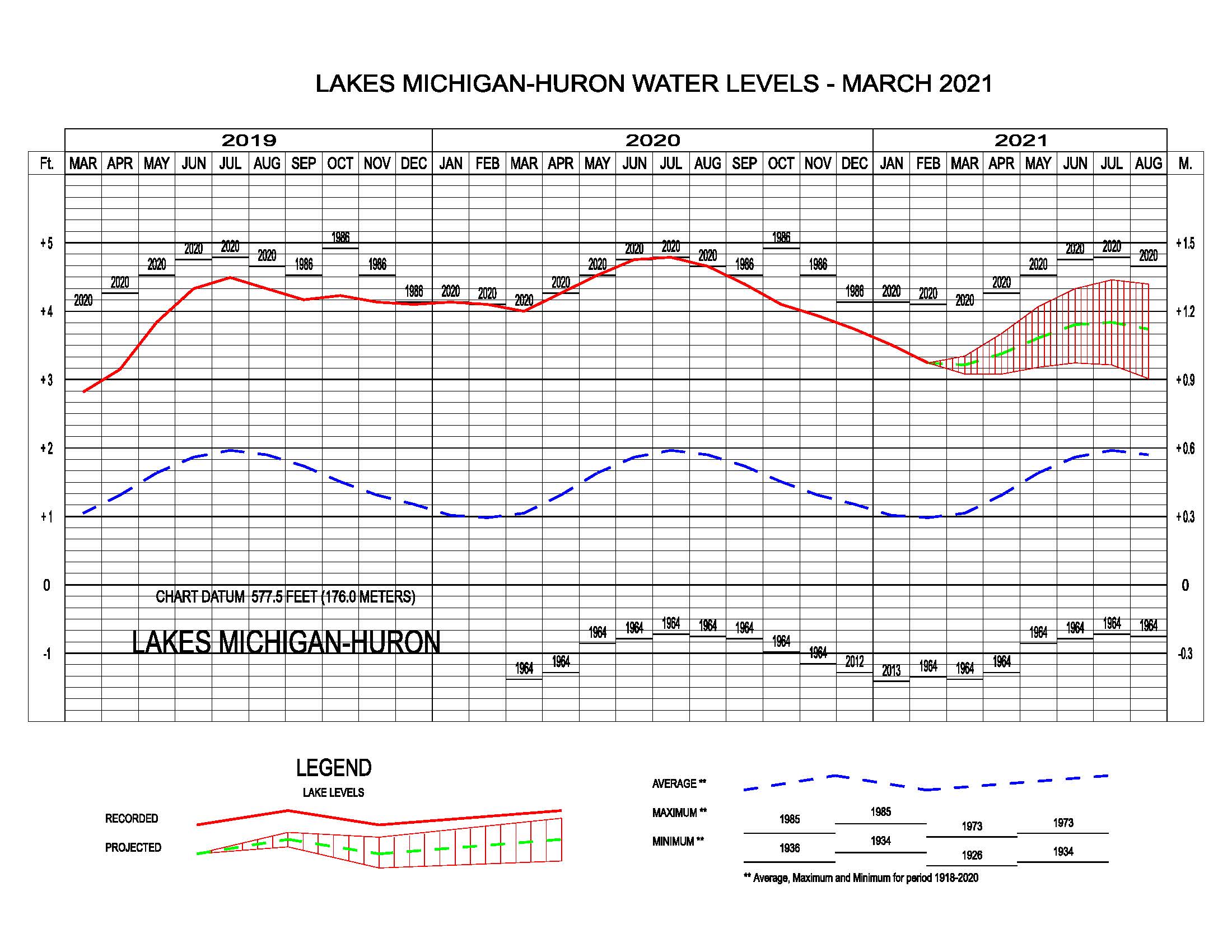
In this image, you can see that current March levels exist around 580.64 feet. This about 9 inches lower than the record monthly high set in 2020. They are about 26 inches above the average water level based on numbers from 1918-2020. Lastly, they are about 55 inches above the record low set in 1964. The next few months are predicted to increase a few inches until around July and then start to decrease. From this image, it is obvious that the lake goes through seasonal periods of high water levels and low water levels. If you want to learn more about why that is, check out our blog “Myth Busting Evaporation on the Great Lakes and other Water Level Fluctuations“.
Audience & Decision Support
This bulletin is intended to be used as a reference for general information about Great Lakes water levels. While this information is not recommended for use in design decisions or long-term planning, a background knowledge of Great Lakes water levels can help municipalities, managers, engineers, and planners understand the annual cycle of lake levels in addition to monthly patterns and variability before gathering supplementary data. Current water levels can be compared with the previous year’s records to put current conditions into a historical perspective. Furthermore, it can help to increase preparedness by allowing users to anticipate what conditions may arise in the near future. Viewing the full monthly report provides users with a brief description of the Basin’s hydrology for the previous month and includes preliminary data regarding precipitation, inflow, and outflow measurements for each lake that can also be used to anticipate associated issues and assist in planning.