


February 17, 2020
By Lydia Salus, Coastal Resilience Project Assistant, Wisconsin Sea Grant
Coastal storms are an annual occurrence on Lake Michigan but this fall and winter season, Lake Michigan’s southeastern Wisconsin’s coastal communities experienced large storms that caused millions of dollars of damage. In this blog, we answer four questions that explore how water levels and coastal storms interact with each other and their potential impact on coastal hazards.
How do coastal storms combine with water levels to cause erosion?
Coastal erosion and recession are largely driven by waves removing material from the base of the bluff or bank. Wave action at the toe of a bluff removes sediment that would otherwise “protect” the bluff slope from erosion. When that material is gone, waves can further erode the intact bluff materials. In doing so, they create a steeper bluff profile which makes bluffs vulnerable to slope failures and face erosion. High water levels also play into this by allowing waves to reach higher elevations on the shoreline where they can erode coastal bluffs and batter shoreline infrastructure.
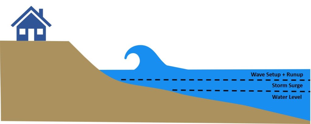
One way to think about how storms interact with high water levels is through wave impact height, which is the height above the top of the beach at which the waves reach. Wave impact height is a combination of the water level of the Lake, the storm surge height, and wave setup and runup (Figure 1). Storm surge is the “piling up” of water along the coast due to storm winds and atmospheric pressure gradients. Incorporating all of these factors into the wave impact height gives a better measure of how waves can erode the coast compared to wave height alone. Coastal storms can increase the wave impact height by creating storm surge and large waves. High water levels provide an elevated baseline for high wave impact height when coastal storms do occur. Wave impact height was studied in Lake Michigan by Brown et al. 2005 who found that generally, as wave impact height increases so do erosion and recession rates. Importantly, the material that a bluff is made from (clays and sands) will either contribute to or impede erosion.

Figure 1. Components of wave impact height
What time of year are coastal storm impacts the greatest?
Lake Michigan typically experiences the most coastal storms during the late fall and winter seasons. The impacts of these storms are the greatest when waves can come into direct contact with the shoreline. These impacts can be seen when there is low ice cover on the Lake. Low ice cover combined with intense storm events generating large waves and extreme storm surge can contribute to significant erosion, particularly during periods of high lake levels (Wuebbles et al. n.d.). While certain types of ice (Ice and Erosion: Helpful or Harmful?) can contribute to erosion, nearshore ice can also prevent waves generated by coastal storms from reaching the shoreline.
Is the intensity and frequency of coastal storms changing?
According to scientists and experts across the Great Lakes Region, two changing conditions in the Great Lakes are likely to contribute to further erosion of Lake Michigan’s shoreline; (1) increased storm intensity and frequency and (2) reduced ice cover in the winter.
The intensity of extreme precipitation events has increased in the last five decades for the Great Lakes (USGCRP 2017) and is projected to continue increasing. Winter, especially, is expected to get wetter and see more storms. This could mean more coastal storms that cause storm surge and large waves.
Lake Michigan has also seen a significant decrease in both its average and maximum winter ice cover. Ice cover of approximately 20% is considered the point at which the shoreline is completely protected from wave action. Changes in the duration of Lake Michigan’s ice cover are likely to result in more open water conditions through January or February and ice off dates as early as March. This would allow coastal storms to impact the coast more frequently than under historic ice conditions.
Are we seeing an unusually strong season of coastal storms this year?
Strong coastal storms affected southeastern Wisconsin on November 30-December 1, 2019 and on January 11, 2020. Wave data from these storms is not readily available because wave-measuring buoys are removed in the winter; however, one thing we can look at is the storm surge resulting from these events. NOAA operates a gauge within Milwaukee Harbor that records fluctuations in Lake Michigan’s water surface every six minutes. The time-series of water level fluctuations for these two events are shown below (Figures 2 and 3). The peak water level measured on December 1, 2019 was the fourth highest recorded at the gauge since 1980 and the peak water level on January 11, 2020 was the third highest.
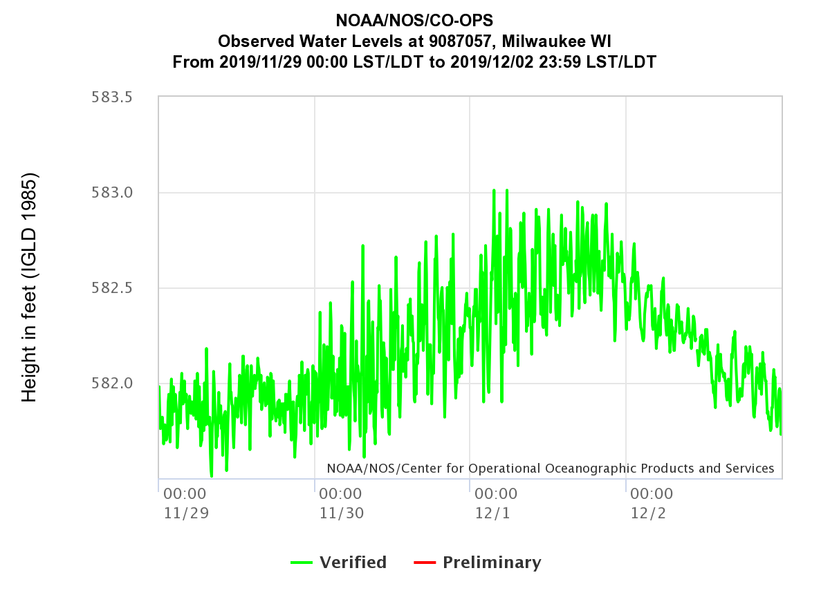
Figure 2. Observed water levels 11-29-2019 to 12-02-2019
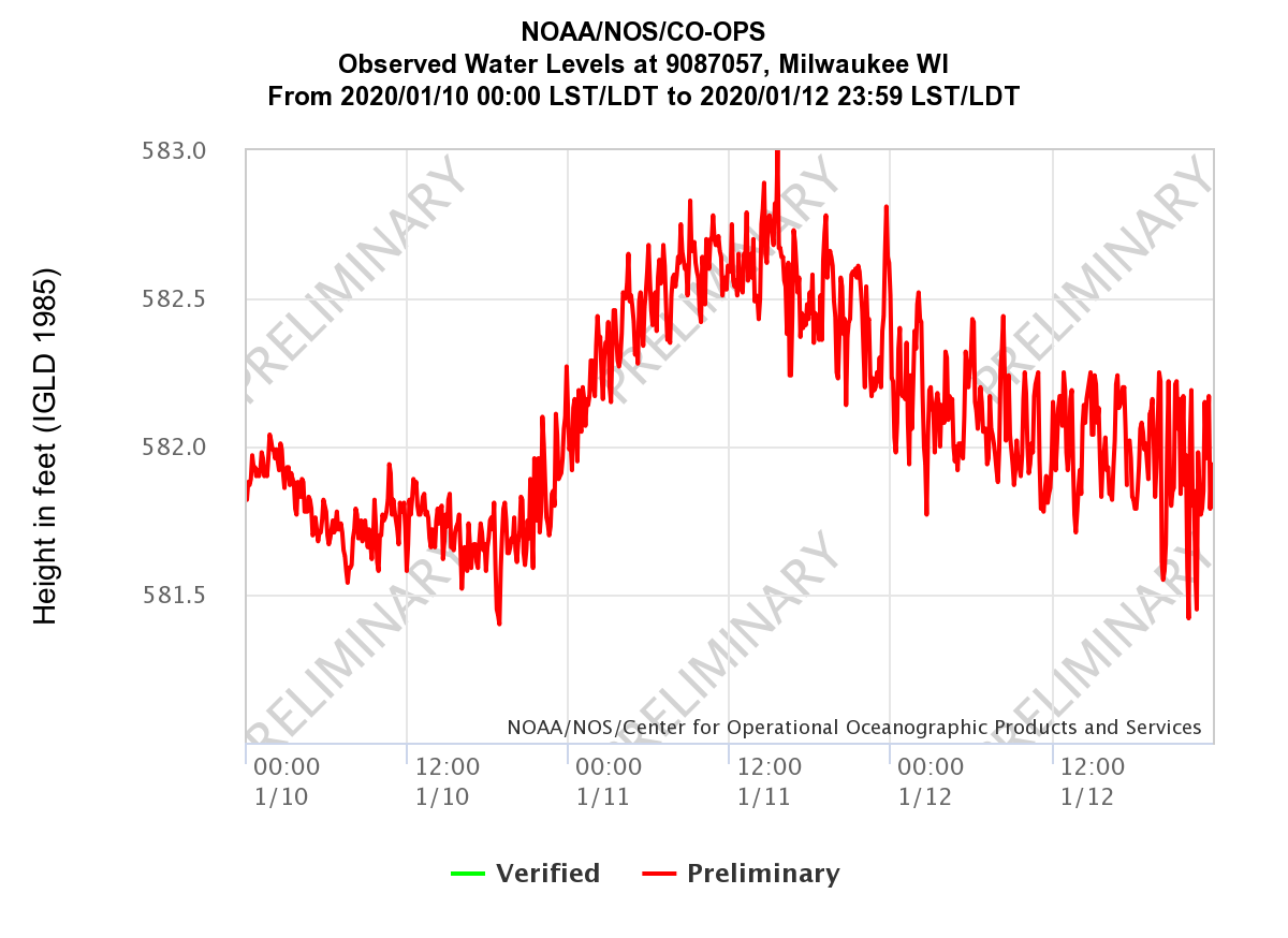
Figure 3. Observed water levels 01-10-2020
The peak water levels on these days is compared to the average Lake Michigan water level for that day to calculate the height of the storm surge. The storms surge on December 1, 2019 was approximately 1.4 feet and January 11, 2020 was approximately 1.5 feet. While neither event exceeded the record 2.2-foot storm surge for the Milwaukee gauge, both events would land within the top 20 storm surges calculated at the gauge from 1950 to 2010 by the U.S. Army Corps of Engineers (Mebly et al. 2012). Having two storm surge events of these magnitudes occur in consecutive months certainly indicates that we are experiencing a strong coastal storm season on top of record high water levels.
Thinking about these storms in the wave impact height framework, record or near record high water levels coupled with fairly large storm surges set the stage for a high wave impact height. While we don’t have wave measurements, we know from eyewitness reports that the waves were very large during both events. All three of these factors combined to what was likely two very large wave impact height events.
Citations:
Brown, E.A., Wu, C.H., Mickelson, D.M., Edil, T.M. (2005). Factors Controlling Rates of Bluff Recession at Two Sites on Lake Michigan. Journal of Great Lakes Research 31(3), 306-321. https://doi.org/10.1016/S0380-1330(05)70262-8
Melby , J. A., Nadal-Caraballo, N. C., Pagan-Albelo, Y. and Ebersole, B. A. (2012), “Wave Height and Water Level Variability on Lakes Michigan and St. Clair,” U.S. Army Corps of Engineers, TR-12-23 http://greatlakescoast.org/pubs/reports/CHL+TR-12-23.pdf
Wuebbles, D., Cardinale, B., Cherkauer, K., Davidson-Arnott, R., Hellmann, J., Infante, D., Johnson, L., de Loe, R., Lofgren, B., Packman, A., Selenidks, F., Sharma, A., Sohngen, B., Tiboris, M., Vimont, D., Wilson, R., Kunkel, K., Ballinger, A. (n.d.). An Assessment of the Impacts of Climate Change on the Great Lakes. Environmental Law & Policy Center. Chicago, IL. http://elpc.org/wp-content/uploads/2019/03/Great-Lakes-Climate-Change-Report.pdf
U.S. Global Change Research Program (USGCRP) (2017). Climate Science Special Report: Fourth National Climate Assessment, Volume I, [Wuebbles, D.J., D.W. Fahey, K.A. Hibbard, D.J. Dokken, B.C. Stewart, and T.K. Maycock (eds.)]. Washington, DC: USGCRP. doi: 10.7930/J0J964J6.